Stopovers

*This post is part of a series about a road trip completed in 2015. For the first post in this series click here.*

When I lived in Alaska, driving six hours from point A to point B without stopping seemed like the norm. There was beautiful scenery to look at and many animals to keep an eye out for. Nowadays, I find it difficult to drive such a stretch without stopping at least once. Perhaps the highways on the east coast do not provide enough visual stimulation to keep my interest. Or my stamina behind the wheel is waning, who knows?

I usually plan a stop in advance for most long car trips. For instance, my favorite stopover on my NC to DE trip is Eastern Shore of Virginia NWR just north of the Chesapeake Bay Tunnel. The refuge visitor center is secluded, offers a dog walking area, clean bathrooms and is never busy, unlike the highway rest stop less than a mile away.
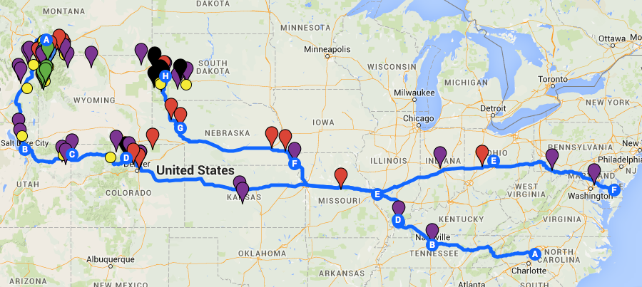
Planning Stopovers

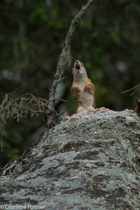
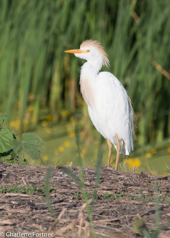
When I planned my summer road trip I wished to maximize the amount of time spent at my destination. This called for extended travel days at the beginning and end of my trip. I carefully looked for places where I could stretch my legs and get in a little bird watching.  Ebird was an essential tool in this part of my research. Their hotspot tool enabled me to find high-density locations nearest to my route.

Planning for safe highway rest stops with dogs is a little more tricky, but there are quite a few websites that provide listings for free dog parks and pet-friendly rest stops along the major US Interstates.

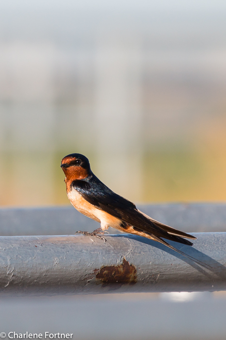
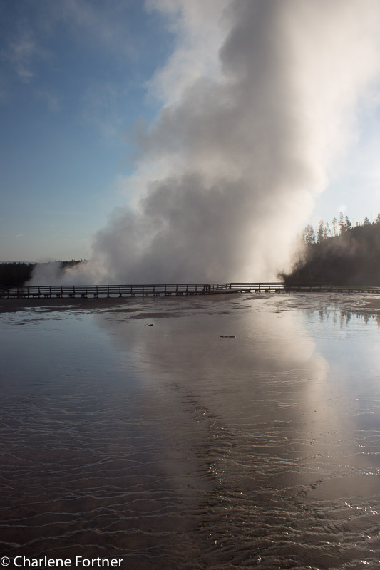
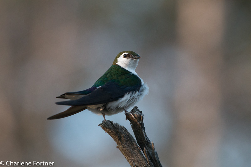
I wrote about my stopover at Mermet Lake WMA already, but I would like to share my favorite photo again, a stunning Great Blue Heron.
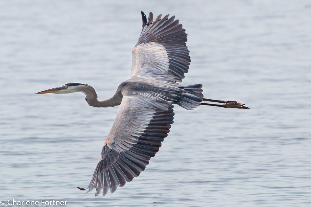
Great Blue Heron
Mermet Lake SFWA
June 2015

Unplanned Breaks

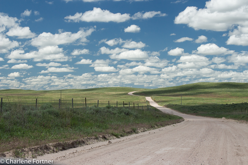
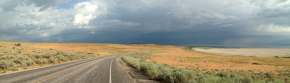
In the case of a road trip, it is always a good idea to keep an eye out for a great opportunity. Unexpected photographic inspirations or unique roadside attractions can pop up without notice. Sometimes traffic, or a lack thereof, allowed me to observe the weather or animals from the road without fear of causing an accident. I was able to slow down to a stop on the road or pull off on the shoulder to snap a few photos along the way.

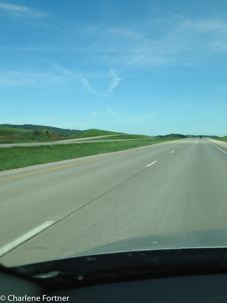
The photos below were taken with my iPhone 5c. The photo on the left was the result of bumper-to-bumper traffic on I-70 in Missouri. The construction work never seemed to end. Occasionally a deserted stretch of highway would allow me to drastically slow down for a quick picture. The photo on the right is from Montana on the way to Devil’s Tower. I wonder if X marked the spot to something spectacular? 🙂

As luck would have it, I came across a small herd of Pronghorn on a secluded byway in northern Utah. Here I was able to stop in the middle of the road for 30 minutes to observe them without worry of oncoming traffic.

As a rule of thumb

  • Always keep a watchful eye on the rear view mirror and the road ahead. I usually check every few seconds. If you have multiple people in your car, designate the look out and rotate.
  • If I cannot pull completely off the road I usually put on a blinker or my emergency lights to alert other drivers.
  • Do not be rude to people who stop to ask you if you are alright (in fact thank them!). You would not want to discourage them from asking the next person who may actually need help.
  • Heed road signs that specify no pull-offs and minimum speed limits.
  • On most highways there are usually exits that would allow you to turn around every mile or so. Consider this rather than slowing down or stopping in heavy traffic areas.
  • If you know of a roadside photo opportunity in advance, consider using Google Maps and Street View to research potential pull-offs.
  • Be prepared for weird (or nasty) looks from passers-by. 🙂

Reminiscing: Road Trip 2015

I never truly presented my thoughts, impressions and photographs from my 2015 cross-country road trip. At least not to the extent I wanted. In reality, I left little time for blogging while I was on the road. Wi-fi hotspots were few and far in between for the majority of my destinations. Cell coverage was deplorable; more about that later!

I wish to devote some time to a collection of posts highlighting destinations, lessons learned, travel tips and photography from 29 days on the road by myself with a dog for company. I hope you will indulge me:

The Whole Trip

In total I would drive nearly 8,000 miles, visiting:

  • 5 National Monuments
  • 4 National Parks
  • 3 National Scenic Highways
  • 10 National Wildlife Refuges
  • 2 State Parks
  • 3 Wilderness Areas
  • 3 Wildlife Management Areas

I hiked more than 40 miles of trails.

I lost 15 pounds on the trip!

Spent 2 nights in a hotel, 22 nights camping and 4 nights with friends.

Added 71 new species to my bird list.

Still wished I had stopped for that camel ride in Montana. 🙂

The Bare Necessities

The total trip costs less than $1800, making the trip come in at around $60 a day! Although, this includes some extra costs like a new backpack, some camping gear and a new tent mid-trip. Gas prices were averaging between $2.50-$2.75 per gallon, although gas around Yellowstone NP and northwestern Wyoming was a bit higher averaging $2.90-$3.10 per gallon. If gas prices remain low in the coming years, I would love to re-run a portion of this road trip!

I booked all of my lodging in advance through the respective state parks or on recreation.gov. While this may have been unnecessary for about half of my lodging options, not having to worry about whether a campground would be full when I got there was worth the effort. Many of the larger state parks and national parks allow reservations up to 6 months or a year prior to your selected date. While most leave some sites available for walk-ins, they are on a first-come-first-serve basis. Prior booking for Yellowstone NP-WY, Badlands NP-SD and Custer SP-SD was a wise choice as each was full when I arrived. On the flip-side, there were 2-3 nights where I wish I could have been more flexible and if I had the proper change, probably would have foregone one reservation to stay closer to one of my destinations (more on that later).

In the Beginning

The first planned stop of the trip was a guilty pleasure, of sorts. The Parthenon: in Nashville, TN. I never knew it was there until watching the first Percy Jackson film. It was in the back of my mind and since I needed to crash somewhere in TN or KY the first night, I though why not?

The full-size replica sits in Centennial Park, southwest of the city center. A walking trail encircles a small lake and the Parthenon. Given my arrival at 0630 in the morning, the park was quiet and parking easy to find off 25th Avenue. The numerous squirrels delighted Ari (my Ibizan Hound) to the point of craziness. I thought he would break off my arms! A few runners and bikers would pass us on our circuit. A brisk walk in the morning was just what I needed to gear up for a very long day of driving ahead!

Parthenon, Centennial Park, Nashville, TN

Flashback to Devils Tower

I’m not an evening person, I’m at my most productive in the morning (without coffee!). With that said, I was really productive this afternoon managing to knock more than 10 things off my running to-do list.

Today I’m flashing back to Devils Tower National Monument in Wyoming. It was just a two-hour drive from my base in Custer State Park. Instead of the short, 1 mile trial circling the base I opted for the longer 3.4-mile Red Beds trail. Not overly challenging and with intermittent shade, it made for a nice mid-morning romp with great views of the country, and of course the main attraction: Devils Tower.

I included my favorite picture of the tower in a previous post, so I decided to share a different perspective this time. The trail gets its name from the exposed soil areas it passes through. This particular photo captures an eroded section that kind of reminds me of the Easter Island statues. The little tree to the center right is only about 2 feet tall.

Red-Beds

Red Beds Trail
Devils Tower NM
Wyoming

Sylvan Lake Trail

Custer State Park’s Sylvan Lake is surrounded by an easy, 1 mile loop trail, officially known as the Sylvan Lake Shore Trail. The trail requires an uphill elevation gain, but it is very short and offers views over the lake. Some scrambling and exposed rock surface areas near the top would make this trail hazardous during wet weather. There are lots of areas for picnicking and stopping along the trail. In most areas it is a wide trail allowing for ease of passing or room for large groups.

Sylvan Lake Custer State Park, SD

Sylvan Lake
Custer State Park, SD

A notable mention for this trail is the abundance in mammal life we came across: red squirrels, chipmunks and marmots. This particular red squirrel did not appreciate me encroaching on his space and decided to “bark” at me. Hilariously his mighty stance was nothing compared to the squeak of his roar.

Red Squirrel Custer State Park Sylvan Lake Shore Trail

Red Squirrel
Custer State Park
Sylvan Lake Shore Trail

Chipmunk, species unidentified Custer State Park Sylvan Lake Shore Trail

Chipmunk, species unidentified
Custer State Park
Sylvan Lake Shore Trail

Bird of the Day: Barn Swallow

Barn Swallow Cheyenne Bottoms WA, KS July 2015

Barn Swallow
Cheyenne Bottoms WA, KS
July 2015

Swallows…

An enigma for me as a photographer. Wicked fast in flight, frustratingly so! Occasionally though, they do sit still and pose. 🙂

Throughout my trip I saw swallows and possibly swifts in many locations. Identifying them in flight is not always easy and I’m sad to say that on more than half of the occasions that I spotted them, I didn’t try. Some species are easier than others, of course, and I spent some time familiarizing myself with key identification markers that make it easier. As my trip progressed it became easier to spot the species that I frequently saw… Cliff Sparrows and their white foreheads and Bank Swallows and their breast band. Violet-green Swallows quickly became my favorite for their brilliant coloring. But I can’t deny that a familiar face is always nice, and the Barn Swallow was a staple among many of the species that I encountered on my trip.

Flashback: Road Trip 06/18

Rolling_Sandhills_NE

I know that I have posted this photo before, but it is one of my favorites from such a memorable afternoon. It epitomizes the road conditions of at least 30% of my trip: dirt/sandy roads winding along the landscape.

West-central Nebraska, north of Oshkosh on Rd. 75 heading towards Crescent Lake National Wildlife Refuge. I could not have asked for better weather to accompany the scenery. Beautiful white fluffy clouds and bright blue skies as far as the eye can see. A very different contrast from the massive thunderstorm I drove through not one hour before.

I would not recommend this route in a non-4wd during or following rain.  Patches of gravel along the sandy areas are all that provide traction. Some places of gravel can be few and far between.

Bird of the Day: Franklin’s Gull

Franklin Gull Bear River MBR, UT Jul. 2015

Franklin Gull
Bear River MBR, UT
Jul. 2015

The first time I encountered a Franklin’s Gull, my first thought was: Laughing Gull. Coming from the east coast, these two species are strikingly similar. Both species are a grey and white gull, with black heads, white eye-rings and red beaks. Juveniles have dark beaks.

Despite their lack of range overlap (some noted exceptions: FRGU migrants on the coasts and LAGU at the Salton Sea of California), some of the differences outlined by my several guides include:

  • White bar and tips on the wing. The Laughing gull simply has black tips.
  • Pale gray central tail feathers, which are not shown in the picture above.
  • My guidebooks also make the distinction that the Franklin’s gull’s white eye ring is more pronounced and more complete around the eye. If you would like to compare it against my photos of the Laughing Gulls, click here.

Bird of the Day: Northern Flicker

Northern Flicker  Custer State Park, SD Jun. 2015

Northern Flicker
Custer State Park, SD
Jun. 2015

During my summer road trip I had the opportunity in the field to view both yellow-shafted and red-shafted Northern Flickers. Yellow-shafted flickers predominately live on the east coast, so my first sighting of a Flicker that looked “unique” was a highlight.

The particular bird above has the red nape and yellowish tinge of underlining on the wing. The lack of a cheek stripe indicates the bird is female.

Even after recognizing the different colored cheek stripe and lack of a red nape, it wasn’t until Yellowstone NP that I witnessed the brilliant red lining of the tail and wings that give the two varieties their names.

Northern Flicker Yellowstone NP July 2015

Northern Flicker
Yellowstone NP
July 2015

More photos of Flickers & Woodpeckers

Bird of the Day: Cattle Egret

Cattle Egret Cheyenne Bottoms WA, KS

Cattle Egret
Cheyenne Bottoms WA, KS
July 2015

During my summer road trip I passed through Cheyenne Bottoms Wildlife Area near Great Bend, KS. Designed for waterfowl, the habitat here was mostly large pools of freshwater and marsh. While there, I came across a large flock of Cattle Egrets. Most of them still in breeding plumage.

More photos of Cattle Egrets

Yellowstone NP

There is so much to say about this wonderful national park. So much so, I want to wait and do it justice at a later date, so this post will be in the captions.

Elk pretty much go wherever they want.

Elk pretty much go wherever they want.

A great place to look for Harlequin Ducks is LeHardy Rapids just south of the Hayden Valley.

A great place to look for Harlequin Ducks is LeHardy Rapids just south of the Hayden Valley.

Old Faithful, which I saw twice in one day.

Old Faithful, which I saw twice in one day.

Grand Canyon of Yellowstone, Lower Falls from Artist's Point

Grand Canyon of Yellowstone, Lower Falls from Artist’s Point

Grotto Geyser, scared me half to death as I was watching it and all of a sudden began its show.

Grotto Geyser, scared me half to death as I was watching it and all of a sudden began its show.

Just before sunrise with a full moon.

Just before sunrise with a full moon.

The circular polarize made this one quite surreal. I normally don't include people in my photos, but this one just fit.

The circular polarize made this one quite surreal. I normally don’t include people in my photos, but this one just fit.

Edge of Grand Prismatic Spring. I was disappointed that the trail that goes up the mountain behind to overlook the spring was closed. Probably for safety.

Edge of Grand Prismatic Spring. I was disappointed that the trail that goes up the mountain behind to overlook the spring was closed. Probably for safety.

Getting up super early has its advantages, one: no crowds and no parking hassles, second: great lighting.

Getting up super early has its advantages, one: no crowds and no parking hassles, second: great lighting.

Morning on Yellowstone Lake. I still haven't figured out if I need to straighten this or just leave it.

Morning on Yellowstone Lake. I still haven’t figured out if I need to straighten this or just leave it.

Finally still! Violet-green Swallow.

Finally still! Violet-green Swallow.