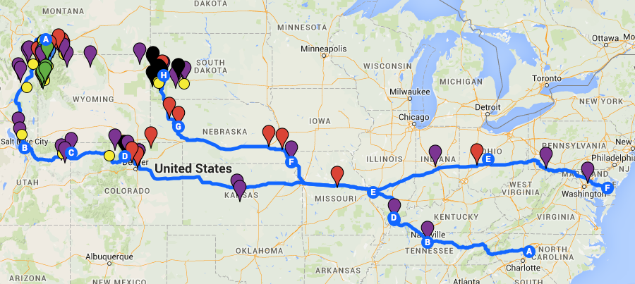
In just 10 days I’ll be heading west to the Black Hills and Yellowstone areas of South Dakota and Montana, USA. Months of cursory and serious planning will culminate in 29 days on the road and an additional 5-7 days in Delaware.

A good friend curiously asked me a few days ago, “How did you plan this?” Well…
Step 1: Where am I going? Why am I going there?
This step is by far the easiest, but also the most time consuming. Years ago, I compiled a list of 30-35 trips I wanted to complete while I am still able, ranging in duration and activity level to specific times of the year. Looking at my budget and season, I determined the highlights of this particular trip would be the Badlands and Yellowstone.
Since I am traveling by myself (the dog counts, doesn’t he?) the hard questions that come after deciding on a destination are easier than if you have to consider the interests and travel styles of many travel partners. I used Google Maps to set up a custom map. I researched as many online and print sources (guidebooks, travel websites like Tripadvisor, local and state tourism websites, chamber of commerce, eBird for birding hotspots, etc.) to add pins for EVERYTHING I want to see. Trust me, it can be a bit overwhelming when you start adding hundreds of dots to the map!! This process is the most fun, and depending on your transportation and your time commitment, the farther outside your immediate location you can explore. During this part I did NOT do in-depth research into any of the places I was adding, just preliminary to determine whether it was something I was interested in.
I had originally decided to travel north after Yellowstone to Glacier National Park and along the Canadian border to several National Wildlife Refuge hotspots in Montana and North Dakota. I finally settled on a southerly path through Salt Lake City and Denver. It didn’t save me any money or time to make the switch, but there were a lot more things to see with shorter travel time between them. That itinerary change essentially wasted probably 20-30 hours of dedicated research; but I kept my notes for future trips.
My reasons for traveling to these areas play a role in the locations I add. My interests are photography, birding, hiking and scenery. While I enjoy museums, this particular trip needs to be as dog-friendly as possible. I’ll be boarding Ari for two sections of my trip, so I will get to visit a few.
Step 2: Setting an Itinerary
Not as fun as the initial research, setting an itinerary can be quite challenging. During this part it is essential not to overestimate your abilities (something I regularly do, will I ever learn my lesson?). Important things to consider:
- What places are dog-friendly, which are not? Can those that are not be done from the car (birding) or will I need to board him (like the National Parks)?
- What areas or campgrounds would make good hubs?
- What time will I get up? (conversely, What time will I get to bed?)
- What are good locations for photography? Will I want to focus on sunrise & sunset photography? (therefore, depending on my lodging: What type of hassle will I have on getting out to sunrise locations or into the campgrounds if I stay late for sunsets?)
- Depending on the type of trails and my abilities, how long do I think it will take me to comfortably finish a trail?
- Is there just one thing or many things I want to do at a location and how far apart are they?
- What type of (road or foot) traffic should I expect and how will that affect my time?
- Where will I be able to find food, showers (not all campgrounds have them!) and laundry services?
Since I am traveling solo, there are considerations I take when making an itinerary. I try not to stay at small (<10 or 15 sites) campgrounds when possible and preferably at ones where an attendant is on duty. If I’m in bear country I tend to consider trails that are more heavily used so that I’ll not be on the trail alone. I personally prefer the paths less traveled so I walk a fine line with this guideline.
As a photographer with a dog, I’ve limited my activity to mostly daylight hours. There are a few exceptions: the lighting ceremony at Mount Rushmore and astrophotography at Badlands National Park. I researched the civil twilight and sunrise/sunset times for the hubs of my trip (Rapid City SD, Livingston MT, Salt Lake City UT and Denver CO) to determine my general daylight allotment.
Some good advice given to me by a friend years ago was to stay in one place and explore rather than moving camp each day. While I’m trying to hold true to this I will be moving a little bit within each of the 4 sections of my trip. For 34 nights I have 19 lodgings. Granted the last section traveling between Yellowstone and home via Salt Lake and Denver is 10 nights with 9 lodging locations. Setting camp and not having to worry about it will be a great time saver when trying to compose early morning and late evening shots and when exhausted after a long day’s hike.
Once I set a hub (campground) I try to cluster sights to minimize the amount of travel time between them. I didn’t particularly want to spend half the day in my car and would much rather spend more time on location. This is the part when the dots on the map begin to get a little sparse. More in-depth research of cluster areas of dots help me determine which areas to check out. Say I have a cluster of 5 dots and only one of the dots is really promising, I’d give up that cluster in favor of another cluster where there were more places that interested me. Outlying spots of great interest do stay on the map for a couple of reasons: perhaps the weather is bad and its just far enough to provide a reprieve from bad weather and still remain active or perhaps a particular place wasn’t as interesting and I didn’t spend a lot of time there and have time to explore something else. I also keep several back-ups in case of inclement weather. With a dog, I’m limited in what rainy day activities I can participate in, but in the sections where I am boarding him I have more freedom. If it is particularly stormy, it may be cool enough to leave him in the car to see a small museum.
The last part of the itinerary once I’ve identified my hubs and clusters is deciding how to arrange the sights in a way that appeals to my interest. Photography and birding are both better at early morning and evening time frames whereas landscapes, museums, rest and travel time would be appropriate for mid-day. If I am constrained by opening/closing times for attractions I plan to arrive at the one farthest away when it opens and work my way back to maximize the time. Although, this is sometime negated by drastically different open/close times of some attractions.
Step 3: Making Reservations & Fine-tuning
This is the part I hate. Once I’ve locked in and paid for lodging and attractions I have very little wiggle room. I’ve created a document that includes my rough itinerary, short descriptions of the sites I’m visiting and why I wanted to go there, trail descriptions and directions. I’ve included addresses or GPS locations to plug into my Garmin and phone numbers and confirmation numbers for all of my lodging locations. Important documents like rabies certificates, AAA membership and emergency contact sheets are included in my binder. Copies of other important documents are stowed away in case I need them.
Some things I went back and added last minute were:
- Locations of local dog parks. I am always wary of going to these in areas I’m unfamiliar with, but at off times where I’m the only one or just a few other dogs, they are great places to let my dogs stretch their legs.
- Check local events calendars. This was a bust for me, but could be a helpful step for others planning trips. Many areas don’t update their summer calendars until April or May so for my trip I was unable to use these to help create my itinerary. However I will be able to attend some ranger-led walks at various parks which are considered daily events.
- Add screenshots to assist with directions. Using Google and some of my location websites I took screenshots and added them to my itinerary sheets to assist with navigation. I also did this for any large city where I would need to change interstates or take outer loops in case of a need to skip traffic.
- Add alternative trails. Due to the fact I’ve added over 170 miles of trails to my itinerary I felt it prudent to select less strenuous back-ups for several trails in case I want to take it easy or if a particular route becomes closed.
- Add apps to my iPhone to assist with travel information. In addition to the ones I’m guaranteed to use (Wunderground Weather, Merlin Bird ID by Cornell, myRefuge by NWS and GasBuddy), I found several others to try out:
- Chimani Grand Teton, Chimani Yellowstone and Chimani Rocky Mtn.
- Geysers – Created by the NPS and updated to show geyser eruption times.
- Birds Near Me – Uses eBird to update recently located birds up to 31 miles from your location within the past 30 days
- Park Guides by National Geographic – So far I can’t find a lot of great information within the free version of this app, but the map section is enticing enough for me to hold on to it.
- Around Me – I’ve had this one awhile, but haven’t had a good opportunity to use it yet.


